

Kaart van het Hertogdom Limburg en het Graafschap Valkenburg, Nicolaas Visscher, ca. 1690
Map of the County of Limburg, 1690
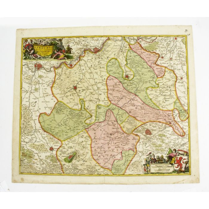
'Limburgi Ducatus et Comitatus Valckenburgi nova descriptio per N. Visscher'. Oud ingekleurde kopergravure, uitgegeven door Nicolaas Visscher te Amsterdam, ca. 1690. Plattegrond van het Hertogdom Limburg en het Graafschap Valkenburg, noordwestelijk georiënteerd, met o.a. Luik, Maastricht, Valkenburg, Sittard en Aken. Linksboven cartouche met de beschrijving, rechtsonder schaalstokken en het wapen met de Limburgse rode leeuw. Afmeting kaart 60,5 x 52 cm. (oud gevouwen). Prijs € 175.-
Handcoloured map by Nicolaas Visscher, depicting the southern part of Limburg, with reaching into Belgium (including Liège and Verviers), as well as Germany (Aachen). Susteren is in the North, Eupen in the South, Spa in the West, and Merkstein in the East. The map has two decorative cartouches, etched by Romeyn de Hooghe.
The Duchy of Limburg was a state of the Holy Roman Empire. It's main territory including the capital Limbourg, which today is within the Belgian province of Liège. From about 1020, Limburg Castle served as the residence of the Counts of Limburg, who in 1100 adopted the ducal title (Herzog in German, Hertog in Dutch) as Dukes of Lower Lorraine, one of the most important and ancient titles in this part of the empire. The extinction of the line in 1283 sparked the War of the Limburg Succession, whereafter Limburg was ruled by the Dukes of Brabant in personal union, eventually being grouped together with the Brabantian "Overmaas" territories bordering it (including Dalhem, Valkenburg, and Hertogenrade), to be one of the Seventeen Provinces of the Burgundian Netherlands. Unlike other parts of this province, the lands of the duchy stayed intact within the Southern Netherlands, under Habsburg control, after the divisions caused by the Eighty Years' War and the War of the Spanish Succession. However finally, after the failed Brabant Revolution in 1789, the duchy's history was terminated with the occupation by French Revolutionary troops in 1793.
This map is taken from Visscher's compiled 'Atlas Minor sive Geographia Compendiosa, Qua Orbis Terrarum, per paucas attamen novissimas tabulas ostenditu'. The Atlas Minor is a fine and comprehensive composite atlas, and one of a series of large atlases compiled and sold by the Visscher family of art dealers and cartographers in the 17th century. Founded by Nicholas Visscher, this work is known for the high quality of engraving, exceptionally fine ornament, and accurate geographical information.

| Beschikbaarheid | Te koop |
|---|